There is a specific kind of overwhelm that hits when you type “California road trip” into a search bar. Suddenly you’re looking at ten different itineraries, none of which agree on anything, all of them telling you to somehow see San Francisco, Big Sur, Yosemite, Los Angeles, and San Diego in seven days without losing your mind.
I’ve been there. Not with California specifically, but with that exact feeling of staring at a map that seems too big to tame, wondering where to even begin. When I was backpacking solo across coastal sections are not fast freeway miles.
Europe for the first time, I had the same paralysis. Too many cities, too many opinions, too little time. The thing that saved me wasn’t finding the “perfect” itinerary. It was finding one that was honest, flexible, and built around how I actually like to travel.
That’s what this guide is for. Not a checklist of every famous landmark. Not a vague “drive down Highway 1 and enjoy the views.” A real, workable California road trip itinerary, built for people who want depth over speed, and who’d rather understand a place than simply pass through it.
The Route at a Glance: San Francisco to San Diego
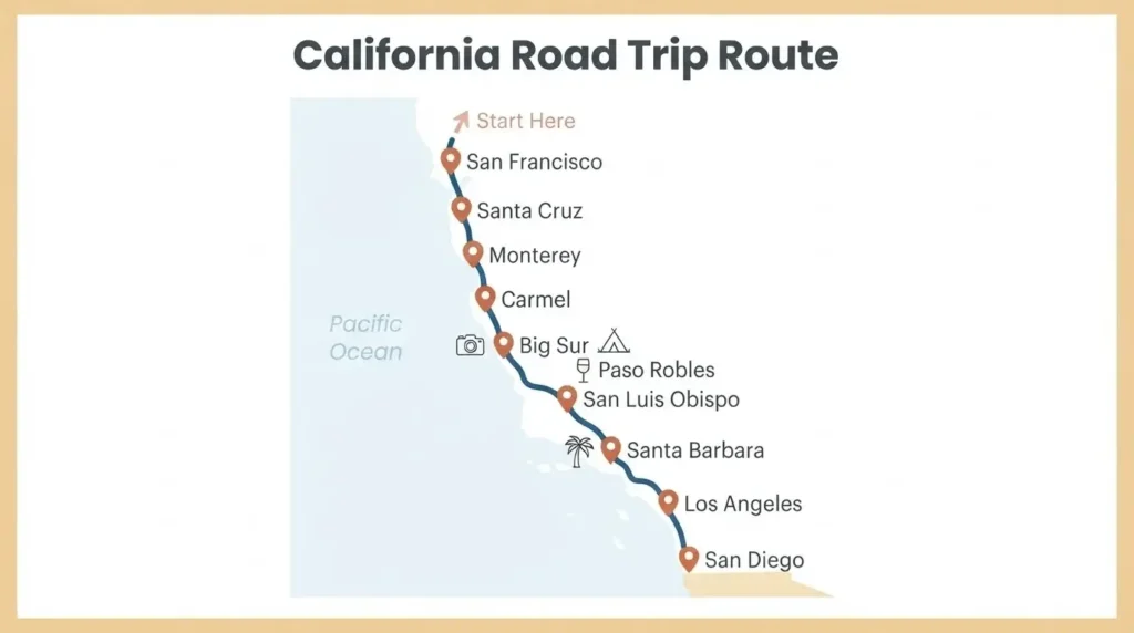
The spine of a California road trip is almost always Highway 1, the Pacific Coast Highway, running along the western edge of the state. The classic direction is north to south, starting in San Francisco and ending in San Diego, and that direction is intentional. When you drive south, the ocean is on your right. That means you’re on the cliff-side of the road with the views, rather than hugging the mountain on the inland side. It’s a genuinely better driving experience, and if you only take one piece of logistics advice from this post, let it be that.
Visit California’s official road trips page is a solid starting point for understanding the broad geographic shape of the state and seeing route options broken down by region, especially if you’re still in the early dreaming stage.
The full San Francisco to San Diego corridor along the coast covers roughly 500 to 550 miles of driving, depending on your detours. That sounds manageable until you realize that most of the iconic coastal sections are not fast freeway miles. Big Sur, for example, is curvy, narrow, and breathtaking in the most literal sense. Plan for slow miles, not freeway miles.
Suggested trip length: 10 days minimum, 14 days ideal. Anything shorter and you’re rushing. Anything longer and you can start adding inland detours like Yosemite or Joshua Tree.
When to Go (and When to Avoid)
This matters more than most itinerary guides will tell you. California has dramatic seasonal variation that directly affects how enjoyable your drive will be.
September through October is widely considered the best window. Summer fog burns off, temperatures along the coast are warm but not brutal, and school is back in session so the crowds thin out considerably. The light in October on the PCH is extraordinary, all gold and long shadows.
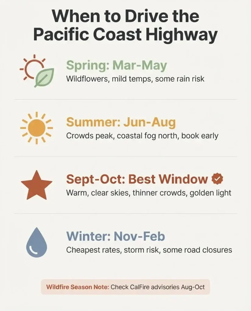
Summer (June through August) sounds ideal but comes with trade-offs. Heavy fog is common along the northern coast in June and July, sometimes lasting until early afternoon. July and August bring peak tourist crowds at Yosemite, Big Sur, and Santa Barbara. Highway 1 can turn into a slow procession of cars during summer weekends.
Spring (March through May) offers wildflowers inland and reasonable coastal weather, but you risk more rainfall and occasional road closures from winter storm damage.
Wildfire season awareness: Late summer and early fall (August through October) is also when California’s wildfire risk peaks. This doesn’t mean don’t go; most years, the road trip corridor is unaffected. But check CalFire’s advisories before you head out, especially if you’re heading into forested areas or national parks.
The 10-Day Itinerary, Stop by Stop
Days 1 and 2: San Francisco
Give yourself two full days in San Francisco before you even think about the car. This city rewards the unhurried visitor, and trying to “see it in a day” is one of the most common mistakes first-timers make.
Spend your first morning in the Mission District. This is one of the most culturally rich neighborhoods in the city, dense with murals, taquerias, and a history that stretches back through waves of immigration. Get breakfast at a local taqueria and just walk. The Mission is the kind of place where the neighborhood itself is the attraction.
Day two, head across the Golden Gate Bridge on foot or by bike, then drop into Sausalito for lunch on the waterfront. The views back toward the city from Sausalito are some of the best you’ll get anywhere, and the town has a slow, art-colony energy that feels completely different from downtown San Francisco.
A few things solo travelers consistently report about San Francisco: the public transit system (BART and Muni) is genuine and functional for most areas, but your car is a liability. Park it at your accommodation and use your feet. Car break-ins are a real problem in tourist-heavy neighborhoods; never leave anything visible in the car, not a bag, not a charger, not a jacket.
Day 3: San Francisco to Santa Cruz (via Half Moon Bay)
Pick up your rental car and start heading south. Resist the urge to skip straight to Monterey. The coastline between San Francisco and Santa Cruz has a quiet, underrated beauty that most itineraries skip entirely.
Half Moon Bay is your first real stop. It’s a small, surf-friendly town with dramatic cliffs and a lovely walkable main street. Grab coffee there and take a short walk out to the bluffs. From there, continue down the coast to Santa Cruz.
Santa Cruz has a personality of its own. The famous Boardwalk amusement park sits right on the beach and is genuinely fun even if you’re not a thrill-seeker; the atmosphere is pure California nostalgia. Wander down to the wharf for fish tacos and watch the sea lions lounge below. Santa Cruz is worth an overnight stop rather than just a drive-through.
Day 4: Santa Cruz to Monterey and Carmel
This leg is short in miles but rich in stops. Arrive in Monterey by mid-morning. Cannery Row, the strip of historic sardine canneries made famous by John Steinbeck, has been reimagined into a stretch of restaurants and shops. It’s commercial but atmospheric. If you have even a passing interest in marine life, the Monterey Bay Aquarium is genuinely world-class. Adult tickets are $65, and the building itself overlooks the open ocean. Book in advance; tickets sell out, especially in summer and on weekends.
After Monterey, drive the short stretch down to Carmel-by-the-Sea. Carmel is a tiny, almost absurdly picturesque village with no street addresses (locals identify homes by name and general location), white-sand beaches, and a long tradition of supporting working artists. Walk Carmel Beach in the late afternoon when the light turns the sand a warm amber color. Have dinner somewhere on Ocean Avenue and take your time.
Day 5: Carmel to Big Sur
This is the day most people have been imagining since they first started planning. The stretch of Highway 1 through Big Sur is approximately 90 miles of some of the most dramatic coastal scenery anywhere in the world. Rocky cliffs, crashing Pacific surf, redwood canyons, and the kind of silence that makes you feel genuinely small in the best possible way.
Big Sur refers to the general region rather than a specific town. There are no traffic lights. There are very few services. That’s the point.
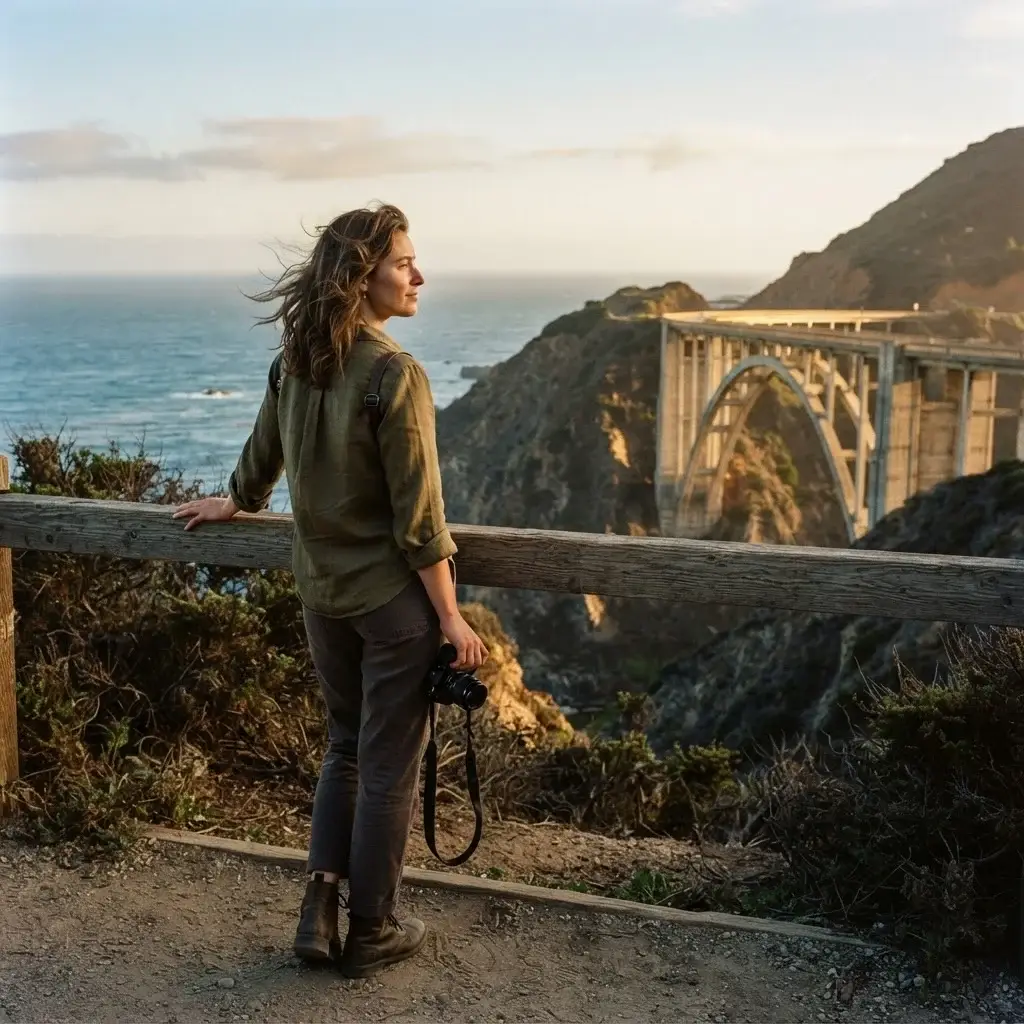
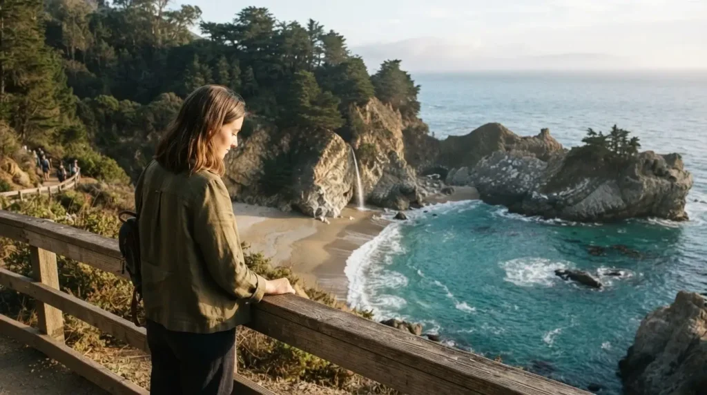
A few key stops you won’t want to skip: Bixby Creek Bridge, one of the most photographed bridges in California, appears about 13 miles south of Carmel. Pull into the turnout north of the bridge for the best angle. Julia Pfeiffer Burns State Park is where you’ll find McWay Falls, the stunning 80-foot waterfall that tumbles directly onto a beach below. The short overlook trail is only about half a mile round trip. Pfeiffer Beach is worth the detour down a narrow dirt road; the sand here runs purple in places due to manganese garnet washed down from the hillside, and the sea stack formations are striking.
As of January 2026, Highway 1 through Big Sur is fully reopened after a period of partial closures due to storm damage. Before any visit, it’s worth quickly checking the Big Sur California Highway 1 conditions page for any updates, as this road does occasionally close after heavy rain.
Plan to spend at least one night in or near Big Sur. Options range from campsites at Pfeiffer Big Sur State Park to lodge rooms at a handful of small properties in the area. Either way, book well in advance. This area fills up fast, especially in summer and fall.
Day 6: Big Sur to San Luis Obispo (via Paso Robles)
As you emerge from Big Sur heading south, the scenery shifts from dramatic cliffs to rolling ranchland and then to wine country. Paso Robles sits about 30 miles inland and is one of California’s most underrated food and wine regions. Zinfandel thrives here in a way it doesn’t anywhere else, and the town square has a genuinely unhurried, small-city energy.
If you’re a wine person, stop at one of the smaller family-run tasting rooms rather than the big commercial operations on the highway. If you’re not a wine person, Paso Robles still rewards a stop for lunch before continuing south to San Luis Obispo (locally called SLO).
SLO is a compact, walkable college town with a strong food scene, a beautiful old mission downtown, and a general sense of contentment that locals will tell you is the California dream distilled. The famous “Bubblegum Alley,” a narrow brick-lined alley covered in chewing gum, is either fascinating or disgusting depending on your perspective. Spend the night here.
Day 7: San Luis Obispo to Santa Barbara
The drive south from SLO to Santa Barbara passes through Pismo Beach, which has wide, open coastline with a breezy, classic California feel, and then through the agricultural heartland of the Santa Ynez Valley before dropping back to the coast at Santa Barbara.
Santa Barbara is often described as California’s Riviera, and while that can sound precious, the reality earns the comparison. The city’s strict architectural codes mean almost everything is built in Spanish Colonial Revival style, white stucco and red tile roofs, creating a visual coherence that most American cities lack. The waterfront along Stearns Wharf is lovely for an evening walk, and State Street running north from the wharf is the city’s main artery for restaurants and local shops.
For food in Santa Barbara, head to the Santa Barbara Public Market or explore the restaurants near the Arts District. The local seafood is exceptional. This is a night to treat yourself, whatever that means for your budget.
Day 8: Santa Barbara to Los Angeles
Los Angeles is a city that confuses and captivates in equal measure. It doesn’t have a tidy “downtown” in the way most cities do; it’s a loose collection of neighborhoods, each with its own identity.
From Santa Barbara, you’ll arrive in LA in roughly two hours, depending on traffic. And yes, traffic is a real factor. Avoid arriving during weekday rush hours (7 to 9 AM, 4 to 7 PM) if you can.
As a solo traveler, the neighborhoods that reward you most are the ones you can explore on foot. Silver Lake and Los Feliz have the coffee shops, record stores, and quiet side streets that actually feel lived-in. Venice Beach and its boardwalk are worth a morning walk for the atmosphere alone. The Getty Center, perched in the hills above Brentwood, has free admission (you pay for parking) and houses one of the world’s great art collections alongside sweeping views of the city and the Pacific. That is a genuinely remarkable thing to experience.
Give LA two nights if you can. One day is not enough to understand it, even partially.
Day 9: Optional Inland Detour – Joshua Tree
If you have a day to spare between LA and San Diego, Joshua Tree National Park deserves serious consideration. The park is roughly two hours east of Los Angeles and sits at the junction of the Mojave and Colorado Deserts. The landscape is like nowhere else on Earth, all twisted Joshua trees, enormous boulders, and night skies so clear they feel theatrical.
The National Park Service’s first-time visitor guide for Joshua Tree is an excellent resource for planning your time. The park is open 24 hours, 365 days a year. Entrance is $30 per vehicle for a 7-day pass. The best time to visit is October through April; summer temperatures regularly exceed 100°F, and hiking in that heat is genuinely dangerous.
Even if you only have a few hours, the Hidden Valley Nature Trail (one mile loop) and Keys View (a short walk to a high overlook with views stretching to the Salton Sea and into Mexico on clear days) give you a real sense of the park without an exhausting full day.
Day 10: San Diego
San Diego often functions as the overlooked finale of the California road trip, a city you drive through on the way to the airport. That’s a mistake. San Diego has a distinct identity and a slower, sunnier energy than Los Angeles.
Spend your final day in the neighborhoods: North Park and South Park for local coffee and independent restaurants, Little Italy for a leisurely breakfast, and Balboa Park for museums, botanical gardens, and the landmark Spanish Colonial architecture that frames some of the city’s best urban walking. The San Diego Zoo sits inside Balboa Park and is considered one of the finest in the world, though it requires a full day of its own.
The Old Town San Diego State Historic Park tells the story of California’s earliest European and Mexican settlement in an engaging, walkable way. From there, the waterfront along the Embarcadero connects the harbor to the USS Midway Museum and offers that classic San Diego scene: blue water, sailboats, and the kind of light that makes everything look slightly better than it is.
The Practical Layer: What You Actually Need to Know
Yosemite: The Inland Addition Worth Knowing About
If your trip runs 12 to 14 days, building in a two-day Yosemite detour is genuinely worth the planning effort. Yosemite sits roughly 4 hours east of San Francisco, so it makes most sense as an add-on to the beginning of your trip, before you start the coastal drive south.
In 2026, Yosemite does not require a timed entry reservation to enter the park. The standard entrance fee is $35 per vehicle, valid for 7 consecutive days. Non-US residents ages 16 and over pay an additional $100 per person fee on top of that. If you’re planning to visit more than one national park on this trip, the America the Beautiful Annual Pass is $80 for US residents and covers entrance to all federal recreation sites for a year. That math works quickly in your favor.
Check current fees, pass options, and any seasonal advisories directly on the Yosemite National Park fees page before you go, since these figures are updated by the NPS directly.
For first-timers in Yosemite, the Valley floor is the main attraction. El Capitan, Half Dome, Yosemite Falls, and Mirror Lake are all accessible from short to moderate trails. Arrive early. The Valley parking lots fill by mid-morning on weekends, and the difference between arriving at 7 AM and arriving at 10 AM is enormous.
Booking Campsites
California state park campsites can be reserved up to 6 months in advance through ReserveCalifornia.com. If camping is part of your plan, mark your reservation date on a calendar and set a reminder. Pfeiffer Big Sur State Park, which consistently ranks as one of California’s top camping destinations, fills up almost immediately when its booking window opens.
Gas and Budget
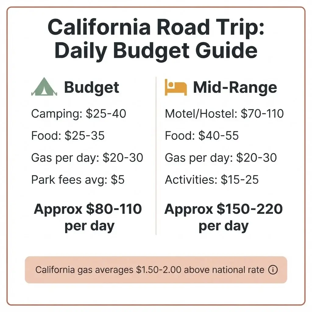
California has some of the highest gas prices in the United States, often $1.50 to $2.00 per gallon above the national average. Budget for this. Use GasBuddy’s trip cost calculator to get a realistic estimate for your specific vehicle before you leave. For a 10-day trip covering roughly 700 to 900 miles (including detours), solo travelers report a realistic all-in daily budget of $120 to $200 per day, covering gas, food, accommodation, and park fees at a mid-range, non-luxury level. Camping brings that number down significantly.
Cell Service on Highway 1
There are long stretches of Highway 1, particularly through Big Sur, where cell service simply does not exist. Download your maps offline in Google Maps or Maps.me before you leave each stop. Download offline playlists and podcasts. This is not a problem; it’s actually one of the most beautiful features of the drive. But being unprepared for it is annoying and, if you’re solo, slightly nerve-inducing.
Driving North to South: A Reminder
One final piece of advice that sounds small but makes a real difference: drive from north to south. The ocean sits on the western side of the road. Southbound, that’s your passenger side if you’re alone, but at every pullout and vista point, you’re stepping out of your car directly toward the view. It just feels right. Northbound, you’re driving on the cliff-side with traffic between you and the ocean, and the vibe is genuinely less magical.
One Thing That Surprises Almost Every Solo Traveler on This Route
People consistently report that the California road trip is one of the least isolating solo travel experiences they’ve had. There’s something about the road, the consecutive days of movement, the nightly conversations at campsite picnic tables or hostel common rooms, that creates unexpected connection. You end up talking to strangers more than you ever do at home.
If you’re on the fence about doing this trip alone, let me tell you what I tell every person who asks: the hesitation you’re feeling right now is exactly the reason to go. You don’t need a travel companion to make this route meaningful. You need curiosity, a rough plan, and the willingness to stop when something unexpected catches your eye.
California is one of the most geographically diverse places in the world. On a single 10-day drive, you’ll move from foggy coastal city to redwood canyon to sun-bleached wine valley to desert. That range, that sheer variety of landscape and culture in one continuous journey, is genuinely rare. It’s the kind of trip that changes how you see what’s possible.
Start planning. Figure out the rest on the road.